CJ Schwarz is my wife. She’s also a mother, a neighbor, a social worker, an acupuncturist, a friend. One of her talents is painting which she took up about three years ago. Her paintings are mostly of subjects CJ and I encountered together (or at least I lived with the painting for the time it took to create). She was inspired by my mother, a professional painter, during the 8 years they knew each other. Mom always took great glee in showing CJ her latest project and sharpening her ability to see.
I paint by instinct and observation. I have always had an appreciation for Nature in its many forms. As a child I spent hours outdoors playing and many a time watching insects, examining flowers and admiring the spring and summer plants and trees. Landscapes and animals are my favorite subject matter. I am captivated by the colors, the light and shapes of a location.
Having always loved animals, I like to pay particularly close attention to an animal’s eyes in painting them. I hope to communicate the animal’s personality and what they might be thinking of in the moment. Lila is an extremely bright dog belonging to a friend of mine. I was captivated by the intensity of her eyes and her beautiful coat.
One can never truly capture the beauty of nature but, hopefully these paintings reflect some of its essence. Nature is not separate from us – we are nature.
The Department of Housing and Urban Development states that housing is affordable if it costs no more than 30% of family income. Affordable housing for all economic groups is a bedrock principal in Columbia. Nonetheless, the three newest apartments in Columbia – – Alta Wilde Lake, The Metropolitan, and Lakehouse (Little Patuxent Square) — are all Class A or “luxury” apartments. This is evident by the ways the apartments describe themselves, and it’s easy to see by their starting rents that they are unaffordable to the secretaries, sales associates, builders, maintenance workers, cooks and waiters that make it all happen.
The Downtown Columbia Plan anticipates construction of 6,250 residential units that will be priced however the market will bear. The February agreement by the County and Howard Hughes Corporation requires there be 900 affordable apartments built downtown, but advocates say only about 500 units will create new family opportunities; 400 units duplicate what is already available in other Columbia Villages. And we’re further increasing the stock of high-rent apartments with Kimco’s proposal of “luxury” apartments at Hickory Ridge Village Center.Continue reading Does Columbia still believe in Affordable Housing?
As stated in the Downtown-wide Design Guidelines, the vision for the Lakefront Core Neighborhood is to bring community life and activity back to the water’s edge. Lakefront Core should be a lively, walkable neighborhood connected and oriented to Lake Kittamaqundi. The existing Lakefront Plaza amenity space shall retain its identity as an important historic and symbolic gathering place in Columbia. Iconic sculptures such as the People Tree and The Hug are landmarks in the community and should be retained within the Lakefront area.
One of the objectives for the development of Downtown Columbia is to create a vibrant, walkable, and economically sustainable community in which to live, work, and play, by creating dense and compact mixed-use neighborhoods. A
sustainable neighborhood should create an urban ecology through an integrated green infrastructure network that includes trees, vegetation, and amenity spaces.
The Design Advisory Panel (DAP) is meeting in the Ellicott Room on Wednesday June 14, 2017 7pm at the County offices to address the Howard Hughes Corp (HHC) newly proposed Columbia Lakefront Core Neighborhood Design Guidelines.
Passing these proposed Guidelines past the DAP is just the first part of their journey to the Planning Board and on up the chain to eventual approval/ disapproval. The DAP recommendation of approval/disapproval will go along with it and be considered by future entities in their deliberations of the proposal.
These proposed Guidelines are intended to be a total replacement of the existing Columbia Downtown wide Design Guidelines for the Lakefront Core Neighborhood.
The footprint of the Lakefront Core Neighborhood is proposed to be expanded to include the current American City building with its parking lot and the Copeland restaurant/parking structure areas.
The maximum allowable building heights for the additional areas proposed to be included in the Neighborhood are to be raised from 9 stories to 15 stories. This new area is on the east side of Little Patuxent Parkway.
The Wincopin Circle street is proposed to be extended southward from its current location to run between the current American City building with its parking lot and the Hug Statue / Columbia Association Lake Kittamaqundi amphitheater area and then on past Whole Foods.
Plans for Columbia Lakefront Core Neighborhood
The Lakefront Core Neighborhood, surrounded by the larger Lakefront Neighborhood, is located between Lake Kittamaquandi and Little Patuxent Parkway and is bounded by Wincopin Circle to the north and the access drive to
Whole Foods/ former Rouse Company Headquarters to the south.
Lakefront Core Neighborhood – Connectivity
The Lakefront area has been isolated from other areas of Downtown Columbia due to the design of Little Patuxent Parkway and topography. The Downtown Columbia Plan proposes three new amenity space corridors extending east
to west that will enhance connectivity between the lake and other downtown destinations.
Lakefront Core Neighborhood Active Frontage Plan
As described in the Downtown Columbia Design Guidelines, Lakefront Core is envisioned as a lively, walkable neighborhood connected and oriented to Lake Kittamaqundi where residences, offices, shops and restaurants as well as entertainment, civic, and cultural uses are all integrated.
Lakefront Core Neighborhood Building Height Plan
In character with this vision, buildings range from 1 to 15 stories in height with shared parking facilities and parking facilities integrated either wholly or partially within individual buildings.
Amenity Space, Downtown Columbia
Open spaces, such as plazas, promenades, and greens, are incorporated within the neighborhood, providing connections back to other Downtown destinations and views to the lake. Natural areas flank and buffer the lake, providing trails and shared-use paths that connect to a larger pedestrian and bicycle network.
The Design Advisory Panel (DAP) is meeting in the Ellicott Room on Wednesday June 14, 2017 7pm at the County offices to address the Howard Hughes Corp (HHC) newly proposed Columbia Lakefront Core Neighborhood Design Guidelines.
If you have any thoughts about these proposals, then please submit them to the DAP. The DAP does not take public testimony at their meetings, but written input can be provided in advance of their meetings by using their web input form at:
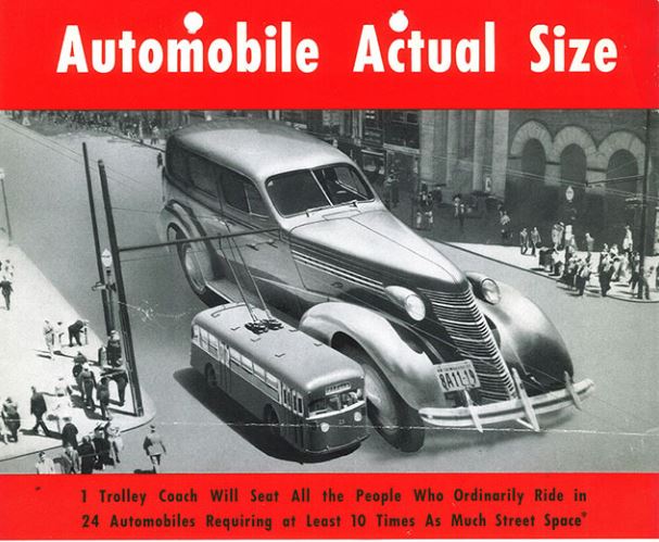
We allocate an awful lot of space to accommodate the automobile and they are a major cause of global warming. To create a sustainable future, we will need to lessen our dependence on cars and develop alternative means of transport.
Howard County is beginning to build this future with consideration of public transportation, development of bike trails, and implementing shared usage of roads. Columbia is grappling with the same issue as we plan for downtown development and rejuvenation of our village centers.
The United States had a very different infrastructure about 100 years ago, until cars took over the roads. How we became a car-centric nation, and what it might look like to share our roads and encourage alternatives to the car are the subject of these articles.
Howard County Complete Streets Policy (DRAFT – October 2016)
Vision: “To ensure that Howard County is a place for individuals of all backgrounds to live and travel freely, safely, and comfortably, public and private roadways in Howard County shall be safe and convenient for residents of all ages and abilities who travel by foot, bicycle, public transportation or automobile, ensuring sustainable communities Countywide.” – Allan H. Kittleman, Howard County Executive, Council Resolution 35-2016.
Scope: The County shall approach every transportation improvement and project phase as an opportunity to create safer, more accessible streets for all users of all ages and abilities, including people who walk, bike, take the bus, and drive cars and trucks. These phases include, but are not limited to: planning, programming, design, right-of-way acquisition, subdivision and land development, new construction, construction engineering, reconstruction, operation, repair, and maintenance. This applies to both new and retrofit projects.
It’s strange to imagine now, but prior to the 1920s, city streets looked dramatically different than they do today. They were considered to be a public space: a place for pedestrians, pushcart vendors, horse-drawn vehicles, streetcars, and children at play.
“Pedestrians were walking in the streets anywhere they wanted, whenever they wanted, usually without looking,” Norton says [Peter Norton, the author of Fighting Traffic: The Dawn of the Motor Age in the American City]. During the 1910s there were few crosswalks painted on the street, and they were generally ignored by pedestrians.
As cars began to spread widely during the 1920s, the consequence of this was predictable: death. Over the first few decades of the century, the number of people killed by cars skyrocketed.
As deaths mounted, anti-car activists sought to slow them down. In 1920, Illustrated Worldwrote, “Every car should be equipped with a device that would hold the speed down to whatever number of miles stipulated for the city in which its owner lived.”
The November 23, 1924, cover of the New York Times shows a common representation of cars during the era — as killing machines. (New York Times)
The turning point came in 1923, says Norton, when 42,000 Cincinnati residents signed a petition for a ballot initiative that would require all cars to have a governor limiting them to 25 miles per hour. Local auto dealers were terrified, and sprang into action, sending letters to every car owner in the city and taking out advertisements against the measure.
Most notably, auto industry groups took control of a series of meetings convened by Herbert Hoover (then secretary of commerce) to create a model traffic law that could be used by cities across the country. Due to their influence, the product of those meetings — the 1928 ModelMunicipal Traffic Ordinance — was largely based off traffic law in Los Angeles, which had enacted strict pedestrian controls in 1925.
Ultimately, both the word jaywalking and the concept that pedestrians shouldn’t walk freely on streets became so deeply entrenched that few people know this history. “The campaign was extremely successful,” Norton says. “It totally changed the message about what streets are for.”
[For more on the auto industry’s campaign to assure that cars had primary use of roads, read the whole article at the link below.]
Murder Machines: Why cars will kill 30,000 Americans this year
by Hunter Oatman-Stanford (Collectors Weekly), March 10, 2014
“If a kid is hit in a street in 2014, I think our first reaction would be to ask, ‘What parent is so neglectful that they let their child play in the street?,’” says Norton [Peter Norton, the author of Fighting Traffic: The Dawn of the Motor Age in the American City]. In 1914, it was pretty much the opposite. It was more like, ‘What evil bastard would drive their speeding car where a kid might be playing?’ That tells us how much our outlook on the public street has changed—blaming the driver was really automatic then.”
1909 Cartoon (Library of Congress)
As cities attempt to undo years of car-oriented development by rebuilding streets that better incorporate public transit, bicycle facilities, and pedestrian needs, the existing bias towards automobiles is making the fight to transform streets just as intense as when cars first arrived in the urban landscape.
“The fact that changes like redesigning streets for bike lanes set off such strong reactions today is a great analogy to what was going on in the ’20s,” says Fried. “There’s a huge status-quo bias that’s inherent in human nature. While I think the changes today are much more beneficial than what was done 80 years ago, the fact that they’re jarring to people comes from the same place. People are very comfortable with things the way they are.”
The U.S. Ended Up Much More Car-Dependent Than Europe
Between the 1920s and 1960s, policies adapting cities to car travel in the United States served as a role model for much of Western Europe. But by the late 1960s, many European cities started refocusing their policies to curb car use by promoting walking, cycling, and public transportation. For the last two decades, in the face of car-dependence, suburban sprawl, and an increasingly unsustainable transportation system, U.S. planners have been looking to Western Europe.
The numbers show the need for change. In 2010, Americans drove for 85 percent of their daily trips, compared to car trip shares of 50 to 65 percent in Europe. Longer trip distances only partially explain the difference. Roughly 30 percent of daily trips are shorter than a mile on either side of the Atlantic. But of those under one-mile trips, Americans drove almost 70 percent of the time, while Europeans made 70 percent of their short trips by bicycle, foot, or public transportation.
The Korean War began June 25, 1950 in response to North Korea’s launch of a full-scale invasion across the 38th Parallel into South Korea. My father, William Harry Schwarz of Baltimore MD, had just graduated on June 10th from Virginia Polytechnic Institute with a Bachelor of Science in Civil Engineering. He married my mother (Jane Frances Imbach) on June 17th.
Lt. William H. Schwarz, Pusan Harbor, Korea
On August 14, 1950, Dad was called to active duty as a 2nd Lieutenant and assigned to the 376th Engineer Construction Battalion, 2nd Army, Ft. Meade MD.
State Army Reserve Unit is Called Up
The Baltimore Sun – July 25, 1950
The 376th Engineer Construction Battalion Reserve, Maryland’s first army unit to be called to the colors, will report for active duty on August 14, the Military District headquarters announced yesterday. The 376th Reserve Battalion, consisting of Negro enlisted men and white officers, returned to Baltimore last night from Fort Belvoir VA where it had gone only the day before to begin two-week summer maneuvers. Continue reading Lt. William H. Schwarz served in Korean War battalion of black enlisted men and white officers


 I paint by instinct and observation. I have always had an appreciation for Nature in its many forms. As a child I spent hours outdoors playing and many a time watching insects, examining flowers and admiring the spring and summer plants and trees. Landscapes and animals are my favorite subject matter. I am captivated by the colors, the light and shapes of a location.