Who knew we have petroleum pipelines running through Howard County MD? On a recent doctor visit out Dorsey Hall Drive in Ellicott City, I discovered these signs for a petroleum pipeline managed by Colonial Pipeline Company. Surprised by my finding, I decided to do some research. Come to find, there are numerous natural gas and hazardous liquid (petroleum) pipelines throughout Howard County and the USA.
Colonial Pipeline right of way (ROW) looking south across Dorsey Hall Dr. and US29 (left) and headed north to Marriottsville and Dorsey Junction in Woodbine (right) [photo by Harry Schwarz]Map showing pipelines traversing Howard County, MD; The Colonial pipeline is indicated by the red line (map by National Pipeline Mapping System (NPMS) Public Viewer)
Pipeline Basics
by The Pipeline and Hazardous Materials Safety Administration, US Dept of Transportation (PHMSA)
The energy transportation network of the United States consists of over 2.5 million miles of pipelines. That’s enough to circle the earth about 100 times. These pipelines are operated by approximately 3,000 companies, large and small.
Most hazardous liquid and gas transmission pipelines are located underground in rights-of-way (ROW). A ROW consists of consecutive property easements acquired by, or granted to, the pipeline company. The ROW provides sufficient space to perform pipeline maintenance and inspections, as well as a clear zone where encroachments can be monitored and prevented. Continue reading Howard County has a “Dakota Access” pipeline right in our back yard
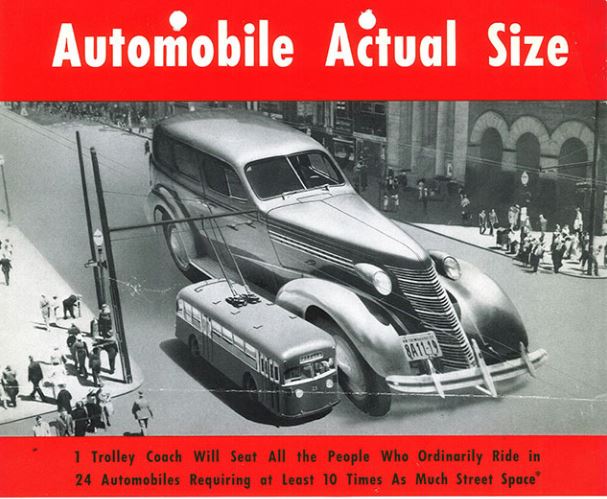
We allocate an awful lot of space to accommodate the automobile and they are a major cause of global warming. To create a sustainable future, we will need to lessen our dependence on cars and develop alternative means of transport.
Howard County is beginning to build this future with consideration of public transportation, development of bike trails, and implementing shared usage of roads. Columbia is grappling with the same issue as we plan for downtown development and rejuvenation of our village centers.
The United States had a very different infrastructure about 100 years ago, until cars took over the roads. How we became a car-centric nation, and what it might look like to share our roads and encourage alternatives to the car are the subject of these articles.
Howard County Complete Streets Policy (DRAFT – October 2016)
Vision: “To ensure that Howard County is a place for individuals of all backgrounds to live and travel freely, safely, and comfortably, public and private roadways in Howard County shall be safe and convenient for residents of all ages and abilities who travel by foot, bicycle, public transportation or automobile, ensuring sustainable communities Countywide.” – Allan H. Kittleman, Howard County Executive, Council Resolution 35-2016.
Scope: The County shall approach every transportation improvement and project phase as an opportunity to create safer, more accessible streets for all users of all ages and abilities, including people who walk, bike, take the bus, and drive cars and trucks. These phases include, but are not limited to: planning, programming, design, right-of-way acquisition, subdivision and land development, new construction, construction engineering, reconstruction, operation, repair, and maintenance. This applies to both new and retrofit projects.
It’s strange to imagine now, but prior to the 1920s, city streets looked dramatically different than they do today. They were considered to be a public space: a place for pedestrians, pushcart vendors, horse-drawn vehicles, streetcars, and children at play.
“Pedestrians were walking in the streets anywhere they wanted, whenever they wanted, usually without looking,” Norton says [Peter Norton, the author of Fighting Traffic: The Dawn of the Motor Age in the American City]. During the 1910s there were few crosswalks painted on the street, and they were generally ignored by pedestrians.
As cars began to spread widely during the 1920s, the consequence of this was predictable: death. Over the first few decades of the century, the number of people killed by cars skyrocketed.
As deaths mounted, anti-car activists sought to slow them down. In 1920, Illustrated Worldwrote, “Every car should be equipped with a device that would hold the speed down to whatever number of miles stipulated for the city in which its owner lived.”
The November 23, 1924, cover of the New York Times shows a common representation of cars during the era — as killing machines. (New York Times)
The turning point came in 1923, says Norton, when 42,000 Cincinnati residents signed a petition for a ballot initiative that would require all cars to have a governor limiting them to 25 miles per hour. Local auto dealers were terrified, and sprang into action, sending letters to every car owner in the city and taking out advertisements against the measure.
Most notably, auto industry groups took control of a series of meetings convened by Herbert Hoover (then secretary of commerce) to create a model traffic law that could be used by cities across the country. Due to their influence, the product of those meetings — the 1928 ModelMunicipal Traffic Ordinance — was largely based off traffic law in Los Angeles, which had enacted strict pedestrian controls in 1925.
Ultimately, both the word jaywalking and the concept that pedestrians shouldn’t walk freely on streets became so deeply entrenched that few people know this history. “The campaign was extremely successful,” Norton says. “It totally changed the message about what streets are for.”
[For more on the auto industry’s campaign to assure that cars had primary use of roads, read the whole article at the link below.]
Murder Machines: Why cars will kill 30,000 Americans this year
by Hunter Oatman-Stanford (Collectors Weekly), March 10, 2014
“If a kid is hit in a street in 2014, I think our first reaction would be to ask, ‘What parent is so neglectful that they let their child play in the street?,’” says Norton [Peter Norton, the author of Fighting Traffic: The Dawn of the Motor Age in the American City]. In 1914, it was pretty much the opposite. It was more like, ‘What evil bastard would drive their speeding car where a kid might be playing?’ That tells us how much our outlook on the public street has changed—blaming the driver was really automatic then.”
1909 Cartoon (Library of Congress)
As cities attempt to undo years of car-oriented development by rebuilding streets that better incorporate public transit, bicycle facilities, and pedestrian needs, the existing bias towards automobiles is making the fight to transform streets just as intense as when cars first arrived in the urban landscape.
“The fact that changes like redesigning streets for bike lanes set off such strong reactions today is a great analogy to what was going on in the ’20s,” says Fried. “There’s a huge status-quo bias that’s inherent in human nature. While I think the changes today are much more beneficial than what was done 80 years ago, the fact that they’re jarring to people comes from the same place. People are very comfortable with things the way they are.”
The U.S. Ended Up Much More Car-Dependent Than Europe
Between the 1920s and 1960s, policies adapting cities to car travel in the United States served as a role model for much of Western Europe. But by the late 1960s, many European cities started refocusing their policies to curb car use by promoting walking, cycling, and public transportation. For the last two decades, in the face of car-dependence, suburban sprawl, and an increasingly unsustainable transportation system, U.S. planners have been looking to Western Europe.
The numbers show the need for change. In 2010, Americans drove for 85 percent of their daily trips, compared to car trip shares of 50 to 65 percent in Europe. Longer trip distances only partially explain the difference. Roughly 30 percent of daily trips are shorter than a mile on either side of the Atlantic. But of those under one-mile trips, Americans drove almost 70 percent of the time, while Europeans made 70 percent of their short trips by bicycle, foot, or public transportation.
Howard County has few transportation options for people traveling into DC. Bus Rapid Transit (BRT) may be a relatively inexpensive option.
Montgomery’s bet on an ambitious Bus Rapid Transit system hinges on Route 29
By Luz Lazo (Washington Post), May 13, 2017 – ABRIDGED
Montgomery County’s years-long plan to build a 14-mile Bus Rapid Transit (BRT) line on one of Maryland’s busiest commuter corridors appears to finally be moving from idea to reality.
County Executive Isiah Leggett (D), who has championed BRT as the county’s next major transit undertaking, included $21.5 million for the project in his capital budget. A County Council committee earlier this month signaled its support for the BRT project, voting to send the plan to the full council for approval of funding for the design phase, putting the project one step away from construction — and closer to a 2020 opening.
The plan as it stands would put buses on shoulder lanes for a portion of the route, but also in regular traffic. This decision, which sacrificed earlier plans to have a reversible HOV lane in the southern portion of the route, cut capital costs by more than half to $31.5 million. Officials say the money will pay for new stations, buses, and new bike and pedestrian infrastructure. The county’s portion will be matched with a $10 million federal grant.
“Go West, Young Man” June 04, 2007|By Rob Hiaasen (Baltimore Sun)
. . . . Tom Hicks, a state highway administrator in Maryland, decided to immortalize Cove Fort [the western terminus of I-70, in Utah] in the minds of Marylanders heading west out of Baltimore toward Frederick, Hagerstown and across nine other states connected by I-70. He and another highway man, Paul Farragut of the Baltimore Metropolitan Council, got to thinking about a different kind of mileage sign, one with a bit of geographical whimsy and one that, for more practical reasons, would test a new type style. It’s not often an act of traffic engineering captures the imagination of, well, anyone.